
Crossing the Algarve by car from one end to the other, from Cape St Vincent in Sagres to the mouth of the Guadiana in Vila Real de Santo António, comes to about 160 km. On the A22 (Via do Infante) it takes a little over two hours; but it's on the national roads along the coast that the route comes into its own, with stops at cliffs, fishing villages and barrier islands. Faro Airport sits almost halfway along, 3 km from the city, which makes it easy to start from either end.
What's it like to drive the Algarve from one end to the other?
Driving the Algarve from one end to the other means covering around 160 km between Sagres, in the far southwest, and Vila Real de Santo António, on the border with Spain. On the A22 (Via do Infante) the direct route takes a little over two hours; on the EN125 and the coastal roads, with stops, it easily becomes a three- to seven-day trip. It's the most flexible way to discover the region, because public transport links the coastal towns to each other poorly.
The car solves the problem that most gets in the way of visitors to the Algarve: the prettiest beaches and the most authentic villages rarely sit next to the train station. With your own vehicle, you can reach a clifftop viewpoint in Lagos, eat seafood in Olhão and sleep in a house with a pool in Albufeira all on the same day. Those who prefer to compare transport options before deciding will find the details in our guide on how to get to and around the Algarve.
Before getting behind the wheel, it's worth fixing the geography: the Algarve splits into three strips. The Barlavento, to the west, is the realm of cliffs and a rough sea; the Centro, around Albufeira and the Golden Triangle, gathers the postcard beaches and the marinas; and the Sotavento, to the east, is made of lagoon, islands and a warmer sea. The coast-to-coast route crosses all three, and it's that variation that makes the trip interesting.
The route: from Sagres to Vila Real de Santo António
The logical route runs from west to east: it starts in Sagres (87 km from Faro Airport), passes through Lagos (63 km), Portimão and Praia da Rocha (52 km), Carvoeiro (44 km), Albufeira (26 km), Faro (3 km), Tavira (31 km), Monte Gordo (49 km) and ends in Vila Real de Santo António (53 km). All distances are measured from Faro Airport, which sits almost halfway along and serves as a reference.
There are two parallel roads linking everything. The A22 (Via do Infante) is the inland motorway, fast and with electronic-only tolls. The EN125 runs closer to the sea, with traffic lights and roundabouts, and gives direct access to the villages. The choice isn't "one or the other": the best is to use the A22 for the long hops and the EN125 and municipal roads for the approach to the coast.
| Stage | Coast | Municipality | Distance to Faro |
|---|---|---|---|
| Sagres | Barlavento | Vila do Bispo | 87 km |
| Lagos | Barlavento | Lagos | 63 km |
| Praia da Rocha (Portimão) | Barlavento | Portimão | 52 km |
| Carvoeiro | Centro | Lagoa | 44 km |
| Albufeira | Centro | Albufeira | 26 km |
| Faro | Sotavento | Faro | 3 km |
| Tavira | Sotavento | Tavira | 31 km |
| Monte Gordo | Sotavento | Vila Real de Santo António | 49 km |
| Vila Real de Santo António | Sotavento | Vila Real de Santo António | 53 km |
Reading this table reveals something useful: Faro Airport sits practically at the centre of gravity of the route, 3 km from the city. So whichever direction you travel in, there's always a short half and a long half from the airport — which helps to plan the first and last day, especially if the flight is early or late afternoon.
The Barlavento by car: cliffs and surf
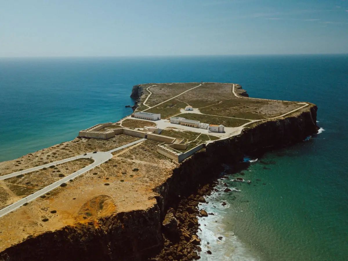
The Barlavento is the most dramatic stretch of the route: high cliffs, a colder and rougher sea, and the villages most tied to surfing. It begins in Sagres, 87 km from Faro, where the Fortress and Cape St Vincent mark the southwesternmost point of mainland Europe. It's a place of wind and late afternoons, with the lighthouse pointing out to the open Atlantic.
Lagos and Ponta da Piedade
Twenty-four km from Sagres lies Lagos (63 km from Faro, around 31,000 inhabitants), the most complete town in the Barlavento. Here you find some of the most photographed beaches in the Algarve: Praia de Dona Ana, Praia do Camilo and the rock arches of Ponta da Piedade, best seen by boat or kayak. The historic centre has walls, baroque churches and reasonably priced restaurants. Those wanting to linger longer here will find options in our guide on where to stay in Lagos.
Portimão, Praia da Rocha and Alvor
Heading east, Portimão (52 km from Faro) opens the door to Praia da Rocha, a wide stretch of sand framed by reddish cliffs and a lively seafront. Right next door, Alvor keeps the more traditional fishing side, with its boardwalk over the lagoon and narrow streets smelling of grilled fish. It's a good spot for a lunch stop before entering the Centro.
The Barlavento is also the part of the coast where the sea rules. In July and August the water rarely tops 19–20 °C and the north wind can pick up in the afternoon, especially in Sagres. For those after waves, it's the right side; for those wanting a warm, calm sea, it's worth knowing the best comes further along, in the Sotavento.
The Centro by car: postcard beaches and marinas
The Centro of the Algarve is the tourist heart of the route and the stretch with the most homes on offer. Between Lagoa and Loulé sit the region's most photographed beaches and the marinas that give their name to the Golden Triangle. It's also here that you find Carvoeiro (44 km from Faro) and Albufeira (26 km, around 44,000 inhabitants), two natural bases for an overnight stop halfway through the trip.
Carvoeiro, Benagil and Praia da Marinha
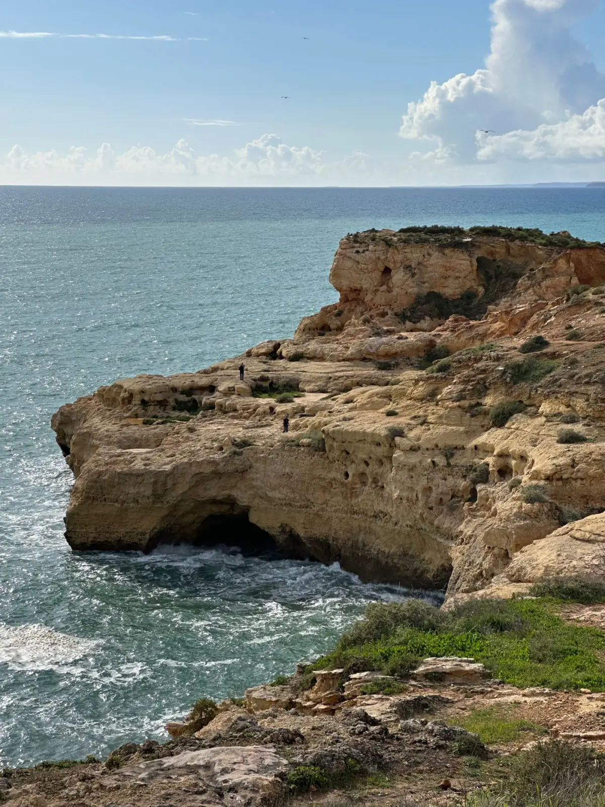
Carvoeiro is a former fishing village tucked into a cove, today one of the most sought-after areas of the Centro. A few minutes' drive away sit the Benagil cave — visitable by kayak, boat or stand-up paddle, since foot access to the inner beach is restricted — and Praia da Marinha, with its arched rock formations. The Seven Hanging Valleys boardwalk links several of these beaches above the cliff and is one of the best coastal trails in the Algarve.
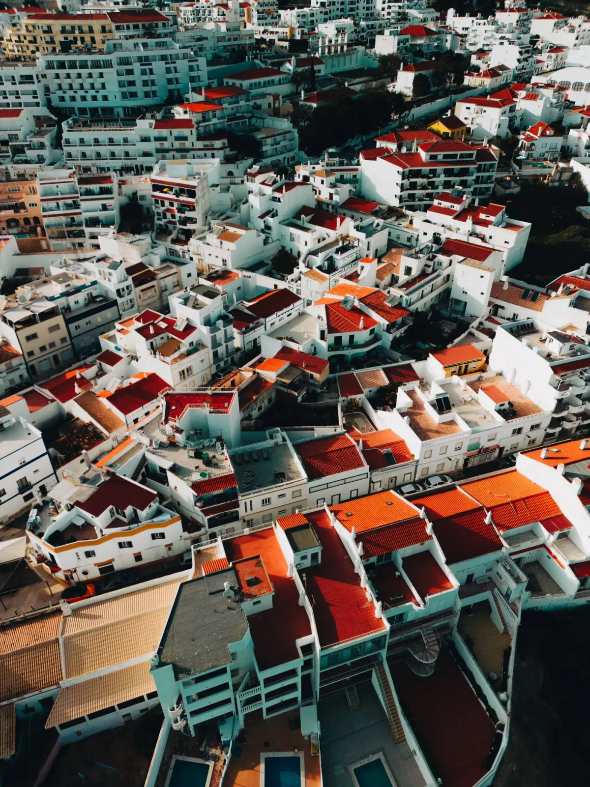
Albufeira and Praia da Falésia
Albufeira is the liveliest town in the Algarve and the best served for restaurants, supermarkets and nightlife. The Old Town keeps the charm of its white streets, while the Oura area gathers the bars. To the east, Praia da Falésia stretches for kilometres of sand beneath ochre-coloured cliffs. For its closeness to the airport (26 km) and its density of services, it's the most practical base for those who just want one house for the whole trip. It's worth comparing with Lagos in our guide Albufeira or Lagos.
If the aim is to split the route into two halves, the Centro is the obvious place for the first base. From Carvoeiro or Albufeira you reach both Lagos and Faro in under 45 minutes, which covers the whole Barlavento and the entrance to the Sotavento without changing home.
The Sotavento by car: lagoon, islands and warm sea
The Sotavento changes the register of the trip: the cliffs give way to wide sands, barrier islands and the warmest sea in the Algarve, which in August reaches close to 22 °C. It's the side sheltered by the Ria Formosa, a system of salt marshes and islands running from Faro to Cacela that gives the beaches a different character — shallower, calmer, with oysters and clams coming straight from the lagoon.
Faro (just 3 km from the airport, around 64,000 inhabitants) is usually overlooked by those passing through in a hurry, but its walled historic centre and the boat access to the islands of the Ria Formosa justify a stop. From here, the road heads east to the border.
Tavira, Santa Luzia and the islands
Tavira (31 km from Faro, around 26,000 inhabitants) is the most beautiful town in the Sotavento, with its bridge over the Gilão river, its churches and the houses with scissor-truss roofs. From here you catch the boat to Tavira Island, a kilometres-long stretch of sand facing the warm sea. Next door, Santa Luzia is the octopus capital, and Cabanas de Tavira has its own barrier island. To explore this area in more depth, read our guide to the Sotavento Algarve.
Monte Gordo and Vila Real de Santo António
The route closes in Monte Gordo (49 km from Faro), with its wide sands and the pine wood separating the beach from the village, and in Vila Real de Santo António (53 km, around 19,000 inhabitants), a Pombaline town on the bank of the Guadiana and the gateway to Spain — Ayamonte is a short ferry crossing away. It's a peaceful ending, of warm sea and a slow pace, very different from the bustle of Albufeira at the start.
Essential stops and viewpoints
The best stops on the route are almost all clifftop viewpoints or lagoon fronts, and hardly any charge an entry fee. It's worth building the route around them, pausing for a coffee or a swim every hour or two of driving. The following list runs from west to east.
- Cape St Vincent (Sagres) — the southwesternmost lighthouse in mainland Europe, unbeatable at sunset.
- Ponta da Piedade (Lagos) — rock arches and grottoes; go down the steps or take the boat trip.
- Seven Hanging Valleys boardwalk (Lagoa) — a clifftop trail linking Praia da Marinha to Benagil.
- Benagil viewpoint — the view over the cave from above; access to the inner beach is by water.
- Historic centre of Tavira — the bridge over the Gilão and the castle viewpoint.
- Olhão marina and markets — the gateway to the islands of the Ria Formosa.
These stops are the thread running through the route: they link the rugged side of the Barlavento to the calm side of the Sotavento without the trip boiling down to hours of motorway. Those wanting to round off the circuit with more ideas beyond the sand will find them in our guide on what to do in the Algarve beyond the beach.
Where to sleep along the route
For a coast-to-coast route, the most common mistake is changing home every day. One or two bases are enough: with a single house in the Centro (Albufeira or Carvoeiro) you cover the Barlavento and the entrance to the Sotavento on day trips; with two bases — one in the Centro, one in the Sotavento, in Tavira — you split the trip into two balanced halves and avoid the daily luggage logistics.
Albufeira is the most practical base for its central position (26 km from the airport) and its density of services. We have several good-value apartments there: the 2-bedroom apartment with pool in Albufeira · 109 m² and the 2-bedroom apartment with pool in Albufeira · 80 m² suit a couple or a small family wanting a pool at the end of the day, while the 2-bedroom apartment in Albufeira · 84 m² is a more modest option in the centre. To close the trip in the Sotavento, the 2-bedroom apartment in Monte Gordo · 91 m² puts the warm sea at the door on the final stretch.
Real-time availability and prices on Homing — book direct, cheaper than Booking, Airbnb and Hotels.com. Click «See dates and price».
These homes are booked direct on Homing, our official partner, and come out cheaper than on Booking, Airbnb or Hotels.com — with no platform commission or hidden fees, with support in Portuguese, English, French and Spanish. Prices vary with the dates and how far ahead you book, so always confirm on each home's page. To understand how much each type of accommodation costs by area and season, see the guide on how much it costs to rent a holiday home in the Algarve.
If you prefer luxury with a private pool rather than an apartment, the Centro is also where the best villas with a private pool are, above all in Vilamoura and Almancil. And if the trip is with family, the Algarve with children guide helps you choose the right area according to the kids' ages and the type of beach.
Practical tips for the Algarve by car
Driving in the Algarve is simple, but three details catch visitors by surprise: the A22's electronic tolls, beach parking in summer and the pace of the EN125. Sorting all three before you set off saves time and money throughout the route.
- A22 tolls: the Via do Infante has no booths; payment is electronic only. Hire the car with a toll device or register your plate with one of the payment systems, or use the EN125 to avoid the charge.
- Beach parking: in July and August, the car parks of the most famous beaches fill up before 10 am. Arrive early or use the wide-sand beaches, which have more space.
- EN125 vs A22: the national road is more scenic but has many traffic lights and speed cameras; for long hops, the motorway is worth the time.
- Fuel: fill up at the stations in the larger towns (Lagos, Portimão, Albufeira, Faro); at the far ends, in Sagres and at the border, there are fewer options.
- Crossing into Spain: from Vila Real de Santo António there's a bridge and a ferry to Ayamonte — handy if you want to stretch the trip into Andalusia.
With these points sorted, the Algarve by car runs without a hitch. The region is compact, the roads are good and the distances between villages rarely exceed 30 to 45 minutes, which leaves most of the day free for the beach and the stops. For the detail on car hire, train and bus, the guide on how to get to and around the Algarve rounds off this route.
How many days for the full route?
The coast-to-coast route works well in four to seven days. In four days you can see the essentials with two bases; in seven, there's time to pause calmly in each area, take a boat trip to Benagil and another to the islands of the Ria Formosa, and not spend the whole day at the wheel. Less than three days forces you to cut stretches and drains the trip of its point.
| Days | Base(s) | What it covers |
|---|---|---|
| 3–4 | 1 base in the Centro | Barlavento (Lagos, Sagres) in one day, Centro and entrance to the Sotavento on the others |
| 5 | 1 base in the Centro + 1 in the Sotavento | Barlavento and Centro at leisure, then Tavira and VRSA |
| 7 | 2 bases | Everything, with boat trips to Benagil and to the islands of the Ria Formosa |
The choice of how many days depends more on the pace you want than on the distance — after all, it's only 160 km from end to end. For a more detailed themed itinerary, with a day-by-day plan, see our 7-day Algarve itinerary, which slots straight into this driving route and indicates where to sleep at each stage.
Sources and references
- Turismo do Algarve (Visit Algarve) — https://www.visitalgarve.pt/
- Wikipédia — Algarve — https://pt.wikipedia.org/wiki/Algarve
- ANA Aeroportos — Aeroporto de Faro — https://www.ana.pt/pt/fao/inicio
- Infraestruturas de Portugal — EN125 e A22 — https://www.infraestruturasdeportugal.pt/
- ICNF — Parque Natural da Ria Formosa — https://www.icnf.pt/
Original editorial article by Maré Algarve, based on official sources (Turismo do Algarve, ICNF, ABAE/Blue Flag, IPMA, INE) and on our experience of holiday rentals in the Algarve. Prices and availability vary — always check each property's page.